Invasive species risks and responses in the Wet Tropics
Climate matching has been completed for current and future climate scenarios in the Wet Tropics and high risk source areas for future weed risks have been identified. We are working through a process of identifying high risk species from these areas by analysing several databases (e.g. Global Invasive Species Database, Rod Randall’s ‘The introduced flora of Australia and its weed status’, the Pacific Island Ecosystems at Risk database and the Atlas of Living Australia). In addition, climate models have been compiled for 30 Class 1, Class 2 and Sleeper and Alert weeds whose distributions intersect the Wet Tropics now or may do in the future.
The dispersal modelling component of the work has already produced results useful for management and ready to be submitted for publication. The most recent results quantify the improvement in likelihood of eradication gained by considering landscape context and structure in management tactics and strategies for invasive species. We have trialled a methodology for understanding weed connectivity in the landscape and will be working with stakeholders over the next year to implement a case study for prioritising weed management taking into account dispersal, connectivity and climate change.
A key component of the adoption strategy has been established to complement existing pest management assessment and prioritisation plans – via a Pest Adaptation Response Plan for relevant species and suites of species - which will be housed on the Far North Queensland Pest Advisory Forum website.
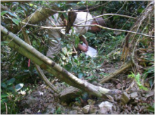
Image: Monitoring for weeds at El Arish in Far North Queensland, Photo by Dr Helen Murphy.
Find out more about the project here
Latest News
- Laws protecting the Great Barrier Reef to be introduced next week, Queensland Premier says - Thu 28th May 2015
- Let’s get serious about protecting wildlife in a warming world - Thu 28th May 2015
- We’ve only monitored a fraction of the Barrier Reef’s species - Thu 28th May 2015
- Great Barrier Reef: warmer waters helping coral-eating starfish thrive - Fri 13th Feb 2015
- You are what you eat—if you're a coral reef fish - Wed 17th Dec 2014

