planning

Dr Marcus Lane leads a group of researchers concerned with improving Australia's environmental policy and planning.  Read more >

This project will partner the region’s key stakeholders to review, trial and evaluate the most effective governance systems and planning foundations for regional and landscape scale adaptation to climate change. In particular, within the context of these governance systems and planning arrangements, it will focus on the potential application of emerging ecosystem service markets to secure landscape scale resilience for biodiversity in the face of climate change.

The key intent of the Project will be to:

Planning systems, governance structures and institutions that capture the traditional knowledge and associations of Indigenous peoples into biodiversity decision-making and management remain elusive. Key planning initiatives in the Wet Tropics region have advanced the institutional capability to engage Indigenous peoples into biodiversity management, including the Wet Tropics Regional Agreement, the Aboriginal Cultural and Natural Resource Management Plan, several Indigenous Land Use Agreements (ILUA), and the nomination for national heritage listing of the Aboriginal cultural values.

Through participatory scenario planning with Torres Strait and Papua New Guinean communities and stakeholders, informed by integrated ecosystem and climate modelling, this project aims to explore potential future scenarios for the region, and identify ‘best bet’ strategies to protect livelihoods and achieve sustainable economic development. This will respond in part to the 2010 Senate Foreign Affairs, Defence and Trade Committee Inquiry, which recommended an analysis of the vulnerability of the Torres Strait to climate change and other future pressures.

The broad goal of this project is to identify strategic priorities for protection and restoration of coastal ecosystems that support the health and resilience of the Great Barrier Reef World Heritage Area, in the context of changing land use, expanding infrastructure, and climate change. More specifically, the project will address three limitations of previous research and application in conservation planning. First, conservation planning has focused principally on snapshots of biodiversity and land uses, as if planning regions were static.
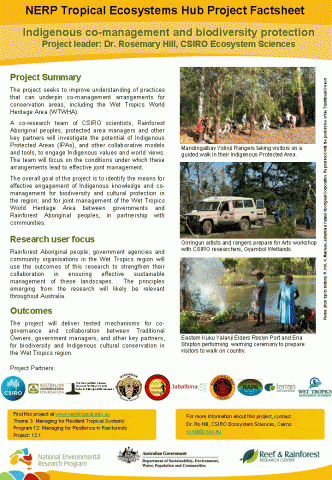
Program 8 has three inter-linked projects that will test the effectiveness of spatial management arrangements (differential use zones) for conserving exploited fish populations in the Great Barrier Reef Marine Park. One project will compare the abundance of fish, corals, and the incidence of coral disease between fringing reefs in the coastal zone that have been closed to fishing at different times in the past with adjacent areas that remain in use by the recreational fishing sector.

Subscribe to RSS - planning